






GEFS is a free, online flight simulator. Whether you are a licensed pilot practicing VFR, an aviation enthusiast or just looking for some fun flying a plane in beautiful sceneries, you can enjoy GEFS quickly, directly from your web browser.
- built on Google Earth: worldwide photo-realistic sceneries
- simulate fixed wing aircraft, helicopter and hot air balloon
- supports joystick control
- realistic flight model (lifting-line theory)
- real-time weather, dynamic wind lift
- multiplayer: fly and chat with other pilots across the globe
- over 30,000 runways and global airspace map
See who's flying!
Full page map
If you are experiencing performance issues with Firefox please read this.
Instructions
- How does the simulator work?
- Where can I fly?
- How to control the simulator?
- How to fly helicopters?
- How to fly Major Tom (balloon)?
- How to set the camera view?
- How to use the map?
- How to enable the Joystick?
- Known issues and troubleshooting
- I want to report a bug!
- I want to unsubscribe from the email alerts
- About
How does the simulator work:
GE Flight Simulator requires to install the Google Earth plug-in. The installation should begin automatically as the game starts.For sound to be enabled, the Flash player must be installed too, but you should already have it.
Finally, if you want to play using a Joystick, you will have to install a browser extension: more details here.
Option bar
The option bar, at the bottom of the game screen, is the main way to interact with the simulator:- The first three yellow button are used to choose your aircraft, location and camera mode.
- The "options" button opens the configuration window: use it to set your pilot callsign, configure controls, weather preferences, etc.
- The "pause", "mute" and "reset" buttons respectively pause the game, mute the sound or reset your flight to the last state.
- The "talk" button shows an input field to type a chat message.
Where can I fly?
Virtually everywhere!- You can pick a preset destination from the option bar.
- The location selector also offer a searh input field in which you can type any destination. The aircraft will be positioned at the chosen place and at an altitude of 1000 feet.
- The last (and best?) way is to use the in-game map to fly from over 30,000 runways in the world.
How to control the simulator?
Keyboard:
Configurable:- Arrows up & down: tilt the aircraft
- Arrow left & right: roll the aircraft (mixed with yaw by default but can be configured)
- A & D: steer the aircraft (Yaw) (only effective when roll/yaw mixing is disabled)
- + & - (or PgUp & PgDn): Increase or decrease throttle
- [: lower the flaps one step (when available)
- ]: raise the flaps one step (when available)
- Home/End: increase/decrease elevator trim
- G: raise or lower the landing gear (when available)
- B: extend/retract air-brakes (when available)
- E: start/stop engine
- SPACE: brakes
- You can configure the keyboard sensitivity from the "option" panel.
- 0 to 9: Directly set throttle by 10% steps
- C: cycle camera mode
- P: Pause the simulation
- S: mute/un-mute sound
- K: set controls mode to "Keyboard"
- M: set controls mode to "Mouse"
- J: set controls mode to "Joystick"
- T: to start typing a chat message
- H: to hide/show the HUD (indicators)
Mouse:
- Mouse acts as a Joystick
- push/pull for tilt
- left/right for roll (mixed with yaw by default but can be configured)
- You can configure the mouse (sensitivity, exponential) from the "option" panel.
- All other keyboard controls (except for arrows) are the same
Joystick:
Note: see how to enable the joystick by installing the browser extension.- Joystick axis and button are by set by default
- If available, yaw is set on twist axis
- You can reconfigure every axis and buttons of the joystick from the "option" panel.
- All other keyboard controls are the same
Flying helicopters:
Helicopters are by definition much more difficult to fly than airplanes. The basic principle is to play with collective pitch (going up and down), cyclic pitch (going forward, backward, right and left) and anti-torque control (rotation/yaw). By default, mouse and keyboard controls are mixing roll and yaw (aileron and rudder). This has to be disabled (in configuration panel) in order to properly fly the helicopter. Idealy, you would have to use a joystick to be accurate enough with the helicopter but the mouse should be enough for a start. In GEFS, the collective pitch is controled using the same input as the throttle for airplanes: if you press '+' several times, the helicopter will lift-off, if you press '-' it will go down. Cyclic pitch can be controled using the arrow keys or the mouse. When roll/yaw mixing is disabled, use the rudder keys (default are keys A & D) for the anti-torque (yaw). The rest is just practice and finesse.Flying Major Tom:
Major Tom is probably the easiest and most relaxing way of flying in GEFS. With just two keys you can take to the skies and look down at the earth. The 'up' arrow key fires the burner and when air is hot enough the balloon will take-off. The 'down' arrow key open the parachute vent to release some air and initiate a descent. To navigate, you can try to climb to different altitudes and reach different direction and speed of wind.Camera:
Five cameras are available. You can choose between these five modes from the option bar or by pressing "C" to cycle through all modes.- Follow: the camera follows the plane at a distance.
- Cockpit: the camera gives a view from the pilot seat.
- Cockpit-less: same as "cockpit" but without visible 3D model.
- Chase: the camera is static but look at the plane.
- Free: this is the default Google Earth camera (uses default controls).
How to use the map?
See the standalone live GEFS map
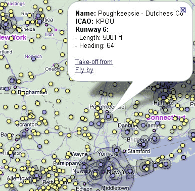
Open the map using the "map" button in the option bar.
Two types of map are available: standard and aeronautical.
Every coloured dot marks a runway threshold. You can click on these dots to open an info balloon in which you can see two links to "take-off from" or "fly by" the clicked runway. When chosing "take-off from", the aircraft should be positioned on the threshold and facing the runway. note: due to some imprecision in the collected data, this is not always true (especially for small airfields).
Dots are colour coded depending on the length of the runway: blue for major runways (>3,000 ft), green for airfield size runways, yellow when length is unknown.
In "Aeronautical" mode, the map shows a layer of airspace areas. This overlay has been generated using DAFIF data. While this can be useful to practice some flight patterns, these data are to be used with this game only and should not be used for real life flying.
How to enable Joystick control:
You need to install the Javascript Joystick Plug-in (by Carl Woffenden)Or get the latest from the project page(Recommanded)
Known issues and troubleshooting:
The plane or some of its parts are not visible:The Google Earth plugin cached half loaded resources. Try the cache clearing procedure described bellow and restart the game.
- Clear you web browser cache
- In your process explorer (Ctrl+Alt+Del), kill the process called geplugin.exe
- Restart the simulator: planes should now be loading properly.
Your joystick model is not working properly:
GEFS uses a browser extension to enable joystick control. This extension has been build and is maintained by Carl Woffenden. You can file bug reports on his Google Code page at http://code.google.com/p/javascript-joystick
GEFS is slow
- GEFS requires a recent computer and a good graphic card in order to achieve confortable frame-rate.
- Make sure GEFS only is running (close other browser tabs and background applications)
- Firefox 4 and 5 are known to run slowly, freeze and even crash the Google Earth plug-in.
A workaround exists:
- type about:config in the browser address bar.
- filter for dom.ipc.plugins.enabled
- if this key does not exist, right click in the table and create a new boolean with preference name dom.ipc.plugins.enabled
- set its value to false.
- restart Firefox.
More details in this blog post.
For any other issues, please submit a bug report (see below, and remember to mention your web browser and operating system version).
Bug report:
You can report bugs or propose new features on the GEFS Google Group.When reporting a bug, please be as descriptive as possible and indicate what operating system and web browser you are using to run this game.
Unsubscribe from the email alert:
About:
I am Xavier, a web developer by day and building GEFS in my free time. I have always been fascinated by flight simulators ever since I ran SubLOGIC FS1 back in the 80s. I built a few simulators over the years, GEFS being my best shot at it I believe.GE Flight Simulator takes full advantage of Google Earth and enables a realistic flight experience in a fantastic scenery.
While simple, the flight models are complete enough to deliver a realistic flight simulation experience. More than just a game, GEFS is a real flight simulator.
From the Piper Cub to the Airbus A380, the range of available aircraft should satisfy every aviation enthousiast. Flight simulation is a vast subject and I hope to be able to improve and enhance this game further. Even though GEFS is built on top of Google Earth, I am not a Google employee and GEFS is not related to - or a product of - Google.
Credits
Aircraft:
- Douglas DC3: Original model from WilliamT (Google 3D Warehouse)
- Alpha Jet: Original model from sletch2003 (Google 3D Warehouse)
- Hughes 269/TH-55: Original model from sletch2003 (Google 3D Warehouse)
- Sopwith Camel F.1: Original model from sletch2003 (Google 3D Warehouse)
- McDonnell Douglas MD-11: Original model from Aakash Kalaria (Turbosquid)
- Sukhoi Su-35: Original model from "mandun" (Google 3D Warehouse)
- Airbus A380: Original model from sletch2003 (Google 3D Warehouse)
Joystick extension:
by Carl Woffenden (http://code.google.com/p/javascript-joystick/)Weather Data:
- Cloud cover images: Barnabu (http://www.barnabu.co.uk)
- Real-time weather data: World Weather Online
Airspace Data (served by Google Fusion Tables):
- Airspace: OpenAir Data from http://soaringweb.org
- Airports and runways: source DAFIF
Thanks to:
- the Google Earth community for all the many buildings and various models around the globe
- the GEFS community for their support, bug reports, suggestions and enthusiasm
- Google for providing the Google Earth platform and the Javascript API through the Google Earth plug-in
© 2011 - GE Flight Simulator - contact@ge-flightsimulator.com